


Farma Nature Reserve: What to see and how to get there

The Siena section of the Reserve, bordered by the Farma stream, distinguishes Siena from Grosseto and contains the beautiful Belagaio State Nature Reserve. This area, which shows its wildness along the Siena-Grosseto road, preserves unique naturalistic aspects with peculiar flora and endemic animal species. The Val di Farma is devoid of significant human settlements, home only to small villages and historical medieval traces of ironworks and mills that have left the area's natural characteristics unaltered. The ironworks, fundamental for iron processing, exploited water and woods for the production of coal and are a precious testimony to human activity in this area.
Farma Nature Reserve
The Farma Nature Reserve, located between Monticiano and Roccastrada, encompasses the middle section of the enchanting uncontaminated valley in which the Farma stream flows, the main contribution of the Merse river, and the upper portion of the Lanzo, a long watercourse that converges in the Ombrone near Paganico. The Sienese area of the Reserve is delimited by the left bank of the Farma stream, whose trajectory represents the border between the province of Siena and that of Grosseto.
Within the protected territory, on Grosseto land, is the Belagaio State Nature Reserve; here, on the Farma-Lanzo ridge, lies the Belagaio, an ancient castle feud, now owned by the State Forestry Corps.
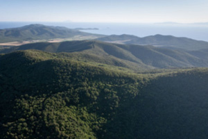
To those transiting the Siena-Grosseto road, at the level of the Petriolo viaduct, the Val di Farma shows itself in all its wildness that could represent a journey back in time, with steep slopes completely covered with vegetation that define a narrow V-shaped valley, in the heart of which the waters of the torrent can be seen from time to time. The entire Val di Farma, and in particular the portion included in the Reserve, preserves naturalistic aspects that are singular for the province of Siena and among the most remarkable of the entire Italian peninsula, with the presence of peculiar flora and rare and endemic animal species, which find here a habitat that is still uncontaminated and immune to human activities.
The Val di Farma is essentially devoid of human settlements, except for the small villages of Iesa, Solaia, Scalvaia and Torniella, whereas it was more densely populated in the past, as were the communication routes along the valley, now disappeared or reduced to paths shrouded in vegetation, bearing witness to human activities in the past.
Exceptional finds of artefacts from the Upper Palaeolithic period (20-10,000 years ago) have been made on some of the alluvial terraces of the Farma, and there are many historical traces dating back to the Middle Ages, a period to which the construction of mills and especially ironworks date, authentic ironworking industries that exploited the energy of water like mills.
The stretch of the Merse near Brenna became a reference point for the city of Siena for milling cereals, while the Farma became an authentic industrial centre for ironworking, an activity to which the local inhabitants, disadvantaged by the scarcity of agricultural land, dedicated themselves very early on. In this way, they exploited the great availability of their forests, for the production of the coal needed for roasting and subsequent processing of the ore.
Near Torniella there was an ironworks and other buildings as early as the 14th century. These were erected on the Farma, all on the stretch of river near the Reserve; an ironworks was also built near the Belagaio Castle by the Lottorenghi, the lords of the castle, and so did the important family of the Ardengheschi counts, who today are the ruins of Castiglione sul Farma. These buildings were abandoned in the 17th and 15th centuries, respectively, but a few ruins remain on the grounds and various working slags are still visible today.
The ironworks known as 'Ruota' was the most important one, but today it is simply called 'Ferriera', and was located on the alluvial plain of the Farma, outside the western boundary of the Reserve. Of this, the entire construction is still observable and, a few hundred metres upstream, also the dam on the stream for water acquisition. Its intense production is evidenced by the large amount of slag that still surrounds it, and it ceased operations between the 19th and 20th centuries.
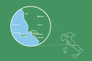
Map Fama Nature Reserve
How to get to the Fama Nature Reserve
The panorama offered by the Pietra and the nature reserve of the same name are easy to reach by driving along the SP73 bis, which connects Torniella to Monticiano. From this main artery, take the Antica via maremmana, a well-preserved old track that is easy to follow, and continue along it until you find a sign on the right (with red and white markings) that begins to climb among the trees up to the belvedere. For greater clarity, below is a map of the route.
Where the Fama Nature Reserve is located
The Fama Nature Reserve, located in the north-east section of the Province of Grosseto, is hidden between Monticiano and Roccastrada. Positioned along the ridge that separates the Val di Farma from the basin of the Fosso Lanzo, the protected area is located in an area of high altitudes, mainly covered by thickets, with limited excursions to pastures and cultivable land.