


Roccastrada: what to see, itineraries and how to get there

Situated on a foundation of trachytic rock that gives it a very special appearance, Roccastrada, the administrative heart of its area, rises 475 metres above sea level and is home to a population of about 2,700. The historical heart of the town is admired thanks to a 13th-century temple consecrated to Saint Nicholas, while recent residential areas emerge around it, among which the 'New Centre' stands out. Nearby are Roccatederighi, Sassofortino, Montemassi, Sticciano and Piloni, each with specific historical, architectural and natural characteristics. Finally, Roccastrada invites you on a historical-cultural journey, starting from the 'Battifolle' promontory and leading to the ancient village of Montemassi, passing by medieval ruins and fascinating cobbled streets.
Roccastrada
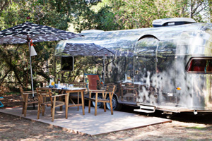
Erected on a foundation of trachytic rock, Roccastrada boasts a prestigious location, a terrace overlooking the slopes of Siena and Grosseto. As the administrative centre of its municipal area, it rises to a height of 475 metres and is home to a population of approximately 2,700. New residential areas have sprung up around its historical centre, where a 13th-century church dedicated to Saint Nicholas is preserved, including the 'New Centre', built around the state road, which, thanks to the architectural quality of the buildings, the availability of parking and transit areas for pedestrians, and a variety of activities and functions, has made this area the true heart of Roccastrada. In this area are the municipal administration with its library, the 19th-century theatre (Teatro dei Concordi), the cinema (Cinema Massimo) and the large town park (Parco del Chiusone). Further south, at the beginning of the historic village, we find a community service centre that includes an office of the Local Health Authority No. 9, a Geriatric Institute and a Vocational Training Centre. Away from the town centre, but still accessible from the central Piazza Gramsci, is a complex of sports and school facilities (middle school).
What to see in the surroundings of Roccastrada
Roccatederighi With almost a thousand residents and located at an altitude of 530 metres, Roccatederighi preserves a well-preserved ancient nucleus, erected on the rocky base, a trachytic buttress of the Sassoforte that contributes to much of its environmental value. The real functional heart is via Roma, the site of production activities and services, where part of the modern construction has developed. The settlement is considerably fractioned along the provincial road until it merges with Sassofortino. Thanks to its isolated position on the top of the rock, like the other localities in this area, it offers a very suggestive panoramic view of the entire Grosseto plain. The surrounding forest is a place for relaxation and invigorating walks.
Sassofortino
Not far from Roccatederighi is Sassofortino, a village of almost 900 residents located at an altitude of 570 metres. Of late medieval origins, due to the abandonment of the castle of Sassoforte, it has seen a recent development along the provincial road, with a contrast between the older and more modern parts. Upstream, between the wooded area of Sassoforte and the more recently built-up area, is the Parco della Sorgente, a site of particular environmental as well as urban interest. Descending to the valley, along a picturesque and steep path (Strada del Peruzzo), is the Pieve di Caminino, an 11th-century Romanesque church.
Montemassi
Montemassi is famous for its fortress, which Simone Martini painted in 'Guidoriccio', and is a village of almost 200 residents, situated 280 metres above sea level. It is currently at the centre of a series of urban and building redevelopment works, as part of the 'Territorial Pact for Development' projects. The area involved includes the current Multifunctional Centre, which is also expected to become a documentation centre on the local archaeological area), the small Rimembranza park and various types of sports facilities, and is conceived as a support structure for cultural activities related to the presence of the castle. Montemassi is also developing along two other directions, behind the ancient Church of Our Lady and in the direction of the stretch of the old provincial road further down.
Sticciano
Situated in the heart of the Monte Leoni area, the village enjoys an extraordinary view that allows it to dominate the entire plain. The road up from the plain offers a view of a magnificent panorama. Sticciano (also known as Sticciano Alto as opposed to the village downstream along the railway), has a few dozen residents and is a medieval village of great value, with a marvellous 12th-century church dedicated to the Most Holy Conception and more commonly known as Pieve di S. Mustiola.
Piloni
A short distance from Torniella, we encounter Piloni, with a hundred or so inhabitants, a recent settlement that in the Catasto Leopoldino of the early 19th century was reported as a cluster of a few dwellings. It has no definite urban structure and its function was probably that of a village of workers linked to forestry activities and stone working, as its name seems to suggest, probably synonymous with pillars or monoliths. The small church, built in 1819 and named S. Maria delle Grazie, is located in the central square. Like Torniella, it has recently seen a strong influx of immigrants from the former Yugoslavia (Bosnia and Macedonia), dedicated to seasonal logging work.
Itineraries from Roccastrada
Roccastrada introduces us to the journey of 'Montemassi at the time of Guidoriccio'. Our journey begins at the promontory of Battifolle, a historic structure from where the Sienese forces orchestrated the 1328 siege, immortalised in Simone Martini's fresco. This hill today offers only traces of its historic siege machine, the Sienese government ordered its destruction to prevent it from falling into enemy hands. From this height, the view extends on three sides from a steep escarpment that allows one to observe the remains of the terracing.
Proceeding towards Montemassi, we head towards the ancient village. From the car park below the fortress, we follow a road up to a group of houses that once demarcated the northern boundary of the hamlet. At the end of the climb, we can see the remains of the medieval walls, including the base of a small rectangular tower, one of the few structures that survived the destruction of 1260 by the Ghibelline government of Siena.
Leaving the main road, we climb a path carved into the rock that takes us to the edge of the precipice. From here, the view sweeps over the houses of the village, whose terracotta roofs blend in with the magnificent surrounding countryside. Turning back, we take the cobbled streets that lead to the historic centre. As we descend towards the hamlet, we notice the heavy limestone projectiles, scattered among the houses, set aside in a corner or arranged neatly by the houses.
The path leads us to the parish church of St. Andrew, located on the southern slopes of the hill and positioned along the main road axis of the southern hamlet of the castle. This religious building, which has been heavily refurbished, features 14th-century construction phases - attributed to Nello di Inghiramo Pannocchieschi - and its interior houses an interesting bronze bell from the period immediately following the Sienese conquest.
Once through the village and down past its walls at an ancient stone portal, we head to the right and climb up to the square where the visit began, while above us rises, still imposing, the fortress on the green cliff.
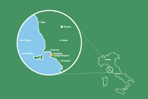
Map of Roccastrada
How to get to Roccastrada
From the North: Take the A1 Autostrada del Sole motorway, exiting at Firenze Certosa and then continue on the Firenze-Siena superstrada towards Siena. Continue along the SS 223 towards Grosseto, then take the SP21 towards Roccastrada - Civitella Marittima - Follonica and finally turn onto the SS 73
for Roccastrada.
From the south: Take the A12 motorway towards Civitavecchia, continue on the SS 1 Aurelia towards Grosseto. At the Braccagni exit, continue along the SP 152 towards Braccagni - Montepescali - Roccastrada, and finally turn onto the SS 73 to Roccastrada.
By train: You can arrive at the Roccastrada train station.
By bus: Bus lines are operated by:
- Autolinee RAMA (www.griforama.it/)
- Autolinee TRAIN (www.trainspa.it/)
Where Roccastrada is located
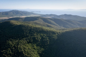
Situated in the heart of Tuscany, precisely in the province of Grosseto, Roccastrada is the connection between the fertile plains of the Maremma Grossetana and the undulating Colline Metallifere of Grosseto.